

|
Oklahoma's Illinois River Information provided by Brock of Oklahoma Fly Fishing
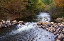
The scenic Illinois River is located
near Tahlequah Oklahoma meandering through the Cookson Hills of
Eastern Oklahoma. The river is well known and primarily thought of
as a canoeing river. The stream head waters begin in Arkansas and
flow through low mountains, hills and valleys for 68 miles before
entering Tenkiller Lake. The useable portion of the river is
generally accepted as beginning at the Lake Frances Dam near Watts
Oklahoma.
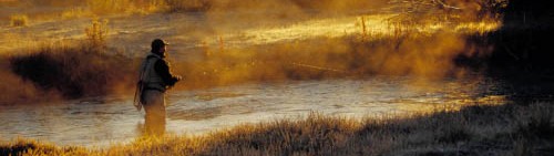
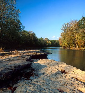
The Illinois River is a wild and scenic stream left in its natural state for the enjoyment of recreationalists and wildlife enthusiasts alike. During the summer months the stream is heavily traveled by canoeist. It is generally a class II river during normal flow conditions. The stream water is noted to be clear to near clear with a gravel and rock stream bed. Some silting occurs in back water eddies at the streams deeper holes. Rock and boulders are sporadically scattered along the length of the stream. In the upper 1/2 to 1/3 portion of the river, steep bluffs, ledges and a bed rock stream bed is common. The stream has numerous trees that have washed in or fallen in the stream in several areas. The roots and trunks of these trees create excellent fish cover as well as a moderate hazard for canoeist. The stream has many gravel bars throughout it's length with short to moderately long holes of varying depth between shallows. The stream is best fished from canoe or flat bottom John boat. Wade fishing at several access points is possible. However, the amount of water that can be covered at these access points is often limited due to deep water up and downstream from these areas. Most public access points will accommodate a hundred yards or more up and downstream for wade fishing. However, during the summer months most of these areas are usually populated by swimmers, sunbathers, beaching canoes and float outfitters delivering their customers to the stream. Floating the river and beaching at likely spots along the rivers length provides greater access to productive water and far more enjoyment of the river, and your fly fishing trip. The "Canoe Hatch" can be a problem for the fly fisher during the summer months. On a typical hot, summer day, hundreds of canoeist and rafters will be on the river. The weekends are very crowded at times. The best time to fish the river is during the weekdays and early morning and late evening hours. If using one of the commercial canoe outfitters along the river, the upper portion of the river (upstream of Chewey Bridge to Round Hollow) receives less canoe traffic than the middle and lower portion of the river. Riverside Floats, one of the last upstream commercial Outfitters, traditionally runs this section of the river when water levels permit. A fourteen mile and seven mile float is available with put-ins upstream of Chewey Bridge or at the bridge for the seven mile trip. The take out point is at the Round Hollow Public Access. To get completely away from summertime canoe traffic, you must travel further upstream. The community of Watts near the Arkansas - Oklahoma State line has one or two canoe outfitters located in the area. This far upper stretch is floatable without much trouble except during the very low water flows in the heat of the summer. This upper stretch is lightly fished with many areas probably not fished at all. The length of the river (68 miles) makes it idea for multi-day floating and overnight camping. However, if one chooses to camp on the river, be very aware of the weather at all times. Even moderate rains upstream can cause the river to rise several feet very quickly. There are over 70 species of fish in the river. Smallmouth Bass, Black Bass, Channel Catfish, Sunfish and larger Perch are the predominate "catchable" species. During the early spring of the year, Sandbass migrate up into the lower portion of the river from Tenkiller Lake on spawning runs. Primary food sources for the fish include crawdads, minnows, hellgrammites, sculpins and Madtoms (black catfish). These Black catfish are small (one to three inches in length), coal black, miniature catfish that burrow into the gravel in the shallows. Smallmouth and Black Bass go "crazy" over these delicacies and a large black weighted woolly bugger or other imitation can be very productive. There are nine major public access points along the length of the river with several other points accessible by riverside canoe outfitters. Access is also possible at low water bridge crossings in the upper portion of the river. The following major access points, not including riverside canoe outfitters, are listed by river miles downstream from the Lake Frances Dam near Watts Oklahoma.
|
|
© 2005 Angler Guide, All Rights Reserved.