Few places in America, and nowhere
outside of Alaska, provide a Wilderness experience to match the sheer
magnitude of the Salmon River often referred as "River of No Return",
the second largest unit of the National Wilderness Preservation System
in the Lower 48 (second in size only to California's Death Valley
Wilderness). This area combines the old Idaho Primitive Area, the Salmon
River Breaks Primitive Area, territory on six national forests, and a
small swath of land managed by the BLM. Senator Frank Church played a
key role in the passage of the Wilderness Act of 1964, and his name was
added to the Wilderness in 1984, shortly before his death.
It is a land of clear rivers, deep
canyons, and rugged mountains. Rich in the history of the west, this
area was the winter home of the Nez Perce Indians, the haunt of early
Chinese placer miners, and domicile to nineteenth century homesteaders
and outlaws.
This vast rugged area containing more
than forty high mountain lakes, rises from 3,500' on the canyon bottoms
of the famous Salmon and Middle Fork Rivers to over 10,000' on Mt.
McGuire. Rainbows, cutthroats, graylings, and brook trout as well as the
illusive golden trout abound in this area.
The Main Salmon River, which runs west
near the northern boundary; and the Middle Fork of the Salmon, which
begins near the southern boundary and runs north for about 104 miles
until it joins the Main. Reaching 6,300 feet from the river bottom, the
canyon carved by the Main Salmon is deeper than most of the earth's
canyons--including the Grand Canyon of the Colorado River--and this
fast-moving waterway has been dubbed the River of No Return.
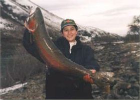
1999 "Women with Bait"
Steelhead Derby Winner, from Riggins, Idaho.
 |
In the northeastern corner of the Wilderness, the Selway River flows
north into the nearby Selway-Bitterroot Wilderness. Trout fishing
usually rates from good to excellent. The Middle Fork, the Selway, and a
portion of the Main Salmon are Wild and Scenic Rivers. Unlike the sheer
walls of the Grand Canyon, these rivers rush below wooded ridges rising
steeply toward the sky, beneath eroded bluffs and ragged, solitary
crags.
The Salmon River Mountains dominate the
interior of the Wilderness. Without a major crest, these mountains splay
out in a multitude of minor crests in all directions, and rise gradually
to wide summits. East of the Middle Fork, the fabulous Bighorn Crags
form a jagged series of summits, at least one topping 10,000 feet. The
Bighorns surround 14 strikingly beautiful clearwater lakes. Hiking up
from the rivers into the mountains brings sudden elevation changes.
Great forests of Douglas fir and
lodgepole pine cover much of the area, with spruce and fir higher up and
ponderosa pine at lower altitudes. The forests are broken by grassy
meadows and sun-washed, treeless slopes.
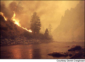
In 2000 Fires
rampaged many areas of the Frank Church "River of No Return".
 |
A dry country, as little as 15 inches of
precipitation falls near the rivers. As much as 50 inches may fall on
the mountaintops, but much of it is snow. Despite the dryness, wildlife
abounds. As many as 370 species have been identified in a single year,
including eight big game animals. A network of 296 maintained trails
(approximately 2,616 miles worth) provides access to this seemingly
endless area, crossing rivers and streams on 114 bridges. This is a
paradise for horse-packers. Thirty-two Forest Service Roads lead to 66
trailheads. Despite the extensive trail system, an amazing 1.5 million
acres remains trail-free. Small planes are allowed to land on several
primitive airstrips dating back to the days before Wilderness
designation. Jet boats are allowed on the Main Salmon.

