|
I
Write San Lorenzo Canyon on a strip of paper, fold it up, and put it in that little tin box of yours marked Hidden Treasures. This gem of an adventure lies between Belen and Socorro, 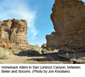 but youll never find it by looking for road signs for there are none. None, that is, until you have already found it. And maybe thats what makes it so perfect only explorers can find it... and only explorers belong there. but youll never find it by looking for road signs for there are none. None, that is, until you have already found it. And maybe thats what makes it so perfect only explorers can find it... and only explorers belong there.
Sliced Bread. San Lorenzo Canyon consists of large rock faces, gigantic formations, caves, slot canyons, chimneys, towers, hoodoos and other geologic wonders that line both sides of a dry creek bed. The geology here is as complex as it is picturesque, showing the results of tectonic plate movement, erosion and volcanic intrusion. The mouth of the canyon is guarded by a huge mesa-like formation that looks a lot like a large loaf of sliced bread. Called an angular unconformity, it features tilted beds of sandstone topped by a horizontal cap.
It was possible for me to drive through the canyon right up to where a rock wall blocked the way. Scrambling up and around that obstruction revealed the upper canyon, with its springs and small streams that appear and then disappear into the sands of the canyon floor. There was even a miniature waterfall when I was there.
Cool Weather Trip. All this makes for a fascinating afternoon of exploring. I would suggest visiting the canyon before the weather gets too hot. If hiking, wear good shoes for the terrain is uneven and sometimes sandy. Bring water. My own recommendation is a daypack with a two- or three-liter water bladder. Horseback riding is another possibility. See www.AcaciaRidingAdventures.com for information. And dont forget, Socorro is 20 miles south of the canyon, with all its restaurants, motels, and plenty of attractions of its own.
Getting There. From the north take Exit 163 (San Acacia) and follow the frontage road south for 2.3 miles. Turn right and go through the tunnel under the freeway. The canyon is another 4½ miles. From the south, take Exit 158 (Lemitar) and travel the frontage road north for 4.6 miles. Then turn left through the tunnel. The road is gravel but well maintained. Eventually youll find yourself driving up a dry braided stream bed. The BLM recommends a 4WD vehicle for the last two miles..
 Jon Knudsen is a freelance writer and occasional guest on "New Mexico In Focus" (PBS). Email him at johnny_mango@yahoo.com. Jon Knudsen is a freelance writer and occasional guest on "New Mexico In Focus" (PBS). Email him at johnny_mango@yahoo.com.
|