History
of Buffalo Bill Reservoir
The
history of Buffalo Bill Reservoir and "Cody Country" is rooted
in the rich lore of the old West. Buffalo Bill State Park was named for
Colonel William F. "Buffalo Bill" Cody, famous as a wild west
showman, promoter and developer. He first came to the region in the
1870's as a guide for a survey expedition and spent the next 20 years
guiding and sponsoring hunting parties in the area. 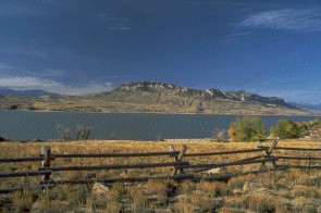 "Buffalo
Bill" Cody was influential in bringing irrigation and agricultural
development into the area and founded the town that bears his name. Some
of the land now occupied by Buffalo Bill State Park was originally owned
by Colonel Cody and was acquired from him by the federal government to
implement the reservoir project. Work began on the dam in 1905. When
completed in 1910 it was the highest dam in the world at 325 feet.
Buffalo Bill State Park was established in 1957 and provided
recreational areas and facilities along the original shoreline. In 1993
an eight year project was completed which raised the crest of the dam 25
feet and increased the reservoir storage capacity. The enlarged
reservoir inundated the former recreation areas which required the
removal of the old park facilities. Buffalo Bill State Park has been
redeveloped as part of the project.
"Buffalo
Bill" Cody was influential in bringing irrigation and agricultural
development into the area and founded the town that bears his name. Some
of the land now occupied by Buffalo Bill State Park was originally owned
by Colonel Cody and was acquired from him by the federal government to
implement the reservoir project. Work began on the dam in 1905. When
completed in 1910 it was the highest dam in the world at 325 feet.
Buffalo Bill State Park was established in 1957 and provided
recreational areas and facilities along the original shoreline. In 1993
an eight year project was completed which raised the crest of the dam 25
feet and increased the reservoir storage capacity. The enlarged
reservoir inundated the former recreation areas which required the
removal of the old park facilities. Buffalo Bill State Park has been
redeveloped as part of the project.
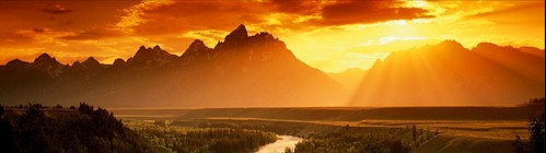
Mountains dominate the
scenery at Buffalo Bill State Park. Shoshone Canyon, the location of the
dam, is framed by Rattlesnake Mountain to the north and Cedar Mountain
(also known as Spirit Mountain) to the south. Further west, along the
north shoreline, lies Logan Mountain. 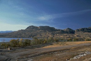 The north and south forks of the Shoshone River are divided by Sheep
Mountain while prominent on the southern skyline is Carter Mountain. All
are part of the Rocky Mountain Absaroka (Ab-Sor'-ka) Range. Elevations
vary from approximately 5,400 feet in the state park to over 10,000 feet
in the Absarokas. The northern sector of Wyoming is world famous for its
outdoor recreation resources. Yellowstone National Park, the world's
first national park, was established in 1872 and annually hosts over 3
million visitors who come to enjoy the park's fishing, camping,
wildlife, geothermal features, and other natural wonders. Grand Teton
National Park, located just south of Yellowstone, is well known for its
spectacular mountain range and associated outdoor recreation
opportunities. Other resources in the region include Shoshone National
Forest, Bridger-Teton National Forest, the
Shoshone and
Big Horn rivers,
and Big Horn Canyon National Recreation Area. These resources, together
with Buffalo Bill State Park, offer unparalleled recreational and
cultural opportunities.
The north and south forks of the Shoshone River are divided by Sheep
Mountain while prominent on the southern skyline is Carter Mountain. All
are part of the Rocky Mountain Absaroka (Ab-Sor'-ka) Range. Elevations
vary from approximately 5,400 feet in the state park to over 10,000 feet
in the Absarokas. The northern sector of Wyoming is world famous for its
outdoor recreation resources. Yellowstone National Park, the world's
first national park, was established in 1872 and annually hosts over 3
million visitors who come to enjoy the park's fishing, camping,
wildlife, geothermal features, and other natural wonders. Grand Teton
National Park, located just south of Yellowstone, is well known for its
spectacular mountain range and associated outdoor recreation
opportunities. Other resources in the region include Shoshone National
Forest, Bridger-Teton National Forest, the
Shoshone and
Big Horn rivers,
and Big Horn Canyon National Recreation Area. These resources, together
with Buffalo Bill State Park, offer unparalleled recreational and
cultural opportunities.
There are two developed campgrounds at
Buffalo Bill State Park.
NORTH SHORE BAY CAMPGROUND (35
sites: 32 pull through sites and 3 designated tent sites) is located
approx. 9 miles west of Cody on US Highway 14-16-20 North Fork Highway.
NORTH FORK CAMPGROUND (62 SITES:
56 pull through sites and 3 designated tent sites) is located approx. 14
miles west of Cody on (North Fork Highway).
Campsites have pull-through parking
(except designated tent sites), table and grills. Hookups are not
available but water hydrants and restrooms are convenient to all sites.
Roads and parking areas are paved.
Campsites are available on a "first come, first served" only.
Reservations cannot be made.
TROUT CREEK GROUP CAMPING AREA is
located within North Fork Campground. This area provides a large shelter
with tables and grill, an area for tents, and enough parking space for a
group of trailers, RV's etc. The group camping area is available on a
reserved use basis only. The shelter use fee of $35. plus the $35.
damage deposit are required in addition to the park entrance and camping
fees.
Please Contact: Cody
Country Chamber of Commerce
P.O. Box 2777 Cody, WY 82414 Phone (307)587-2297
- Motorized vehicles shall be operated
only on roads, trails or areas designated for such use. A valid
operator's license is required.
- All visitors must abide by posted
speed limits.
- Leaving any vehicle or other personal
property unattended for longer than 24 hours is prohibited.
- Camping is permitted for a maximum of
14 consecutive days during any 30 day period. Sites cannot be
reserved.
- Quiet shall be maintained in all areas
used for camping between the hours of 10 p.m. and 6 a.m.
- Areas designated as "day use
only" must be vacated by 10 p.m.
- Pets must be kept on a leash.
- All trash shall be deposited in
containers designated for that purpose. Please use recycle
containers where available. In areas without containers you are
required to pack out your own trash.
- Fires are permitted only in fireplaces
or grills as provided and must be completely extinguished before
leaving.
- The discharge of firearms and
fireworks is prohibited.
- Fishing and boating are permitted
subject to regulations prescribed by the Wyoming Game & Fish
Commission. Fishing from within 20 yards of any boat ramp and/or
dock is prohibited.
TROUT CREEK NATURE TRAIL is
located near the group camping area in the North Fork Campground.
This trail provides a 1/4 mile walk through riparian habitat on the
west side of Trout Creek along the Shoshone River.
EAGLE POINT TRAIL is located
in the Eagle Point Day Use Area approx. 10 miles west of Cody off
the North Fork Highway. This trail is the first phase of a planned
trail system along the north shoreline.
Both of these trails are
handicapped accessible.
Group Facilities: Sheep
Mountain Day Use Area is located adjacent to North Fork Campground
on the south side of the Shoshone River. This area can be reserved
for group picnics and activities.
Included are a large shelter with
tables and grill, playground equipment, horseshoe pits, volleyball
court, basket ball goal, and softball field.
Water hydrant and restroom are
convenient to shelter. A daily fee of $35. is required plus a $35.
refundable damage deposit. Park entrance fees are also required.
This area can be used by small groups, when it is not reserved, with
payment of entrance fee.
Other Things To Do
- Fishing
- Boating
- Camping
- Picnicking
- Relaxing
- SightSeeing
- Photography
- Wildlife viewing
- Windsurfing
- Walking/Hiking
- Bicycling
Facts, Figures and
Important Phone Numbers
Facts, Figures and
Important Phone Numbers
| Main Number |
(307)587-9227 |
| Fax Number |
(307)587-4990 |
| Closest Town |
Cody |
| Hookups |
N/A |
| # of Camping Sites |
9 tent only, 88 tent/trailer |
| Trailer Dump Station |
Yes (2) |
| # of Sandy Beaches |
N/A |
| # of Group Picnic Shelters |
3 |
| # of Covered Shelters |
9 |
| # of Picnic Areas |
9 |
| Playgrounds |
2 |
| # of Restrooms |
16 |
| Public Telephone |
Yes |
| Trails |
Yes |
| Boat Ramp/Dock |
Yes(3) |
| Visitor Center, Museum, Gift
Shop |
and Buffalo Bill Dam Visitor
Center |
| Marina |
N/A |
| Lodge |
Yes, day use only. No
overnight camping |
Other Important Information and
Phone Numbers
Did you Know?.....At
the maximum reservoir elevation of 5,395 feet approximately 8,500
surface acres are covered by water. About 3,500 land acres surround
40 miles of shoreline.
| North Shore Bay
Entrance Station |
(307)527-6274 |
| North Fork
Campground Entrance Station |
(307)527-6057 |
| Buffalo Bill Dam
Visitor Center |
(307)527-6076 |
| Chamber of
Commerce |
(307)587-2297 |
| Emergency |
911 |
| County Sheriff |
(307)527-8700 |
| Game & Fish
Dept. |
(307)527-7125 |
| Forest
Service(Wapiti) |
(307)527-6921 |
| Bureau or
Reclamation |
(307)527-6256 |
| Buffalo Bill
Historical Center |
(307)587-4771 |
| Yellowstone
National Park |
(307)344-7381 |