- Aunt
Molly River Mile:
70
- Directions: East of Ovando to Hwy
141, turn south for 1 3/4 miles, then east for 3
miles to bridge.
- Other Info: Carry in launch.
Open all season. 1184 acre(s).
- Cedar
Meadow River Mile:
64
- Directions: From Helmville take
SR 272 northwest for 4 miles.
- Other Info: Canoes/rafts can be
hand launched from site. Non-motorized watercraft
only for Blackfoot R and its tribs. Open all
season. 3 acre(s).
- River
Junction River
Mile: 53
- Directions: 39 miles east of
Bonner on Hwy 200 to Milepost 39, then 9 miles
southeast on Co. Road.
Stay limit is 7 days. Fee required. Contact the
regional office for fee info.
- Other Info: 6 campsites available
at this site. Canoes/rafts can be hand launched from
site. Road to site is very rough. Non-motorized
watercraft only for Blackfoot R and tribs Open all
season. 179 acre(s).
-
Russell Gates Memorial
River Mile: 40
- Directions: 35 miles east of
Bonner on Hwy 200 to Milepost 35.
Stay limit is 7 days. Fee required. Contact the
regional office for fee info.
- Other Info: Canoes/rafts can be
hand launched from site 12 campsites. Non-motorized
watercraft only for Blackfoot R and tribs Open all
season. 41 acre(s).
-
Sunset Hill River
Mile: 31
- Directions: Opposite the
Clearwater crossing FAS take Sunset Hill Road south.
- Other Info: 2 sites - one is at
junction of Clearwater/Blackfoot Rivers, 21/2 miles
south of Hwy 200. The other one is 41/2 miles south
of Hwy 200. Both provide walk-in access only. Open
all season.
-
Roundup River Mile:
29
- Directions: 26 miles east of
Bonner on Hwy 200 to milepost 26, then west on
Ninemile Prairie Road.
- Other Info: "Raft slide" launch
structure. Non-motorized watercraft only for
Blackfoot R and tribs Open all season.
-
Ninemile Prairie
River Mile: 25
- Directions: 26 miles east of
Bonner on Hwy 200 to Milepost 26, then 4 miles west.
Stay limit is 7 days. Fee required. Contact the
regional office for fee info.
- Other Info: Launching boats at
this site is not advised. Only 2 developed campsites
at this location. Non-motorized watercraft only for
Blackfoot R and its tribs Open all season. 14
acre(s).
-
Corrick's Riverbend
River Mile: 23
- Directions: 26 miles east of
Bonner an Hwy 200 to mile post 26, then 71/2 miles
west on Ninemile Prairie Road.
Stay limit is 7 days. Fee required. Contact the
regional office for fee info.
- Other Info: Non-motorized
watercraft only for the Blackfoot River. Open all
season. 32 acre(s).
-
Belmont Creek River
Mile: 21
- Directions: Located 10 miles east
of Johnsrud FAS and 9 miles west of Roundup FAS on
Ninemile Prairie Road.
- Other Info: Walk-in access only
(approx. 500 yds) boat launching is not advised.
Non-motorized watercraft only for Blackfoot R and
its tribs. Open all season.
- Red
Rocks River Mile:
20
- Directions: Approx. 71/2 miles
east of the Johnsrud FAS along the Corridor Road.
- Other Info: 1/2 mi walk from
parking area to site Open all season.
-
Whitaker Bridge
River Mile: 19
- Directions: Approx. 7 miles east
of Johnsrud FAS on the Corridon Road.
- Other Info: Hand launching of
boats is best done 300 yds downstream at an unnamed
day use site. Non-motorized watercraft only for
Blackfoot R and its tribs Open all season.
-
Thibodeau River
Mile: 18
- Directions: 6 miles east of
Johnsrud FAS on the Corridor Road.
Stay limit is 7 days. Fee required. Contact the
regional office for fee info.
- Other Info: 6 camping sites. Road
is rocky and rough. Boat launching is not advised.
Non-motorized watercraft only for Blackfoot R and
its tribs Open all season.
- Sheep
Flats River Mile:
17
- Directions: 4 1/2 miles east of
the Johnsrud FAS on the Corridon Road.
- Other Info: Numerous roads skirt
this area, and provide several access points to the
river down a steep bank. Non-motorized watercraft
only for Blackfoot R and its tribs Open all
season.
-
Daigles Eddy River
Mile: 16
- Directions: 3 miles northeast of
the Johnsrud FAS on the Corridor Road.
- Other Info: Open all season.
-
Johnsrud Park River
Mile: 13
- Directions: 11 miles east of
Bonner on Hwy 200, then west on gravel road.
Stay limit is 7 days. Fee required. Contact the
regional office for fee info.
- Other Info: Day use shelter,
horseshoe pits, volleyball court, and baseball
diamond at this site. Non-motorized watercraft only
for Blackfoot Rand its tribs Open all season. 18
acre(s).
- K.
Ross Toole River
Mile: 9
- Directions: Information being
updated
- Other Info: Seasonal. Contact
the regional office for open and closure dates.
- Marco
Flats River Mile: 3
- Directions: 21/2 miles northeast
of Bonner on Hwy 200.
- Other Info: Canoes/rafts can be
hand launched from site. Non-motorized watercraft
only for Blackfoot R and its tribs Open all
season. 2 acre(s).
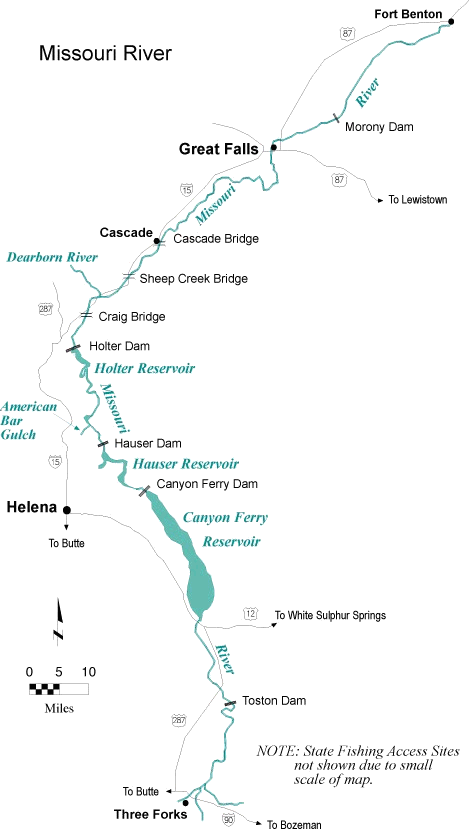
NOTE:
All river Fishing Access Sites (FAS)
are listed in descending order by river mile from
headwaters to mouth. The mouth of a stream is its
confluence with another body of water and is
considered mile 0.