About The Refuge
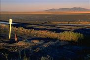 The Bear River Migratory Bird Refuge, managed by
the US Fish and Wildlife Service, lies on the
eastern edge of the Great Basin, just west of
Brigham City, Utah. Directly east lie the
Wellesvilles Mountains, which form the divide
separating those watercourses which eventually lead
to the ocean from those which lead to the Great Salt
Lake. The Bear River, which runs through the heart
of the refuge and lends its name to it, is one of
those which run into the lake.
The Bear River Migratory Bird Refuge, managed by
the US Fish and Wildlife Service, lies on the
eastern edge of the Great Basin, just west of
Brigham City, Utah. Directly east lie the
Wellesvilles Mountains, which form the divide
separating those watercourses which eventually lead
to the ocean from those which lead to the Great Salt
Lake. The Bear River, which runs through the heart
of the refuge and lends its name to it, is one of
those which run into the lake.
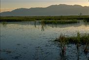
The Refuge, with its fresh water ponds and
canals, is one of the most important resting and
staging areas for migrating waterfowl in North
America. In spring and summer, it is an extremely
productive nesting area for birds like Clark's and
western grebes, American avocet, Wilson's phalarope,
black-necked stilt, snowy egret, and white-faced
ibis.
 Flooding was widespread throughout the Great
Basin in the early 1980s. In southeast Oregon,
Malheur Lake, then a vast marsh within the Malheur
National Wildlife Refuge, grew greatly in size,
killing marsh vegetation which still has not fully
recovered. At Malheur, this flooding caused declines
in grebe productivity but great increases in the
numbers of white-faced ibis and American white
pelicans successfully raising young.
Flooding was widespread throughout the Great
Basin in the early 1980s. In southeast Oregon,
Malheur Lake, then a vast marsh within the Malheur
National Wildlife Refuge, grew greatly in size,
killing marsh vegetation which still has not fully
recovered. At Malheur, this flooding caused declines
in grebe productivity but great increases in the
numbers of white-faced ibis and American white
pelicans successfully raising young.
The Great Salt Lake, the largest body of water
within the Great Basin and, unlike Malheur, as salty
as its name suggests, also flooded. At Bear River
Migratory Bird Refuge, Refuge Headquarters was
destroyed. Worse, miles of canals, many
water-control structures, and vast areas of marsh
were inundated by salt water and in many cases
destroyed. This saltwater flood was not nearly as
benign as the fresh water flooding which occured at Malheur.
While reconstruction of much of the refuge
infrastructure has been completed, there is no
headquarters and no visitor facilities other than an
information kiosk and solar-powered composting
toilet.
If you visit the refuge, then, you are unlikely
to find more than a handful of cars on the loop
road, but many birds. This makes the refuge an ideal
place for bird photography.
Auto Loop
 This refuge is an "auto loop" refuge -
a set of dike roads, forming a loop about ten miles
long, are open for auto traffic. Except for this
road, and a very short boardwalk nature trail, the
refuge is closed to the public.
This refuge is an "auto loop" refuge -
a set of dike roads, forming a loop about ten miles
long, are open for auto traffic. Except for this
road, and a very short boardwalk nature trail, the
refuge is closed to the public.
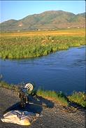
Fortunately, this road passes along canals full
of grebes, with plenty of wading birds feeding on
the vegetation which borders them. Good views of
mudflats, ponds, and marshes can be had from the
road. There are rarely more than a few cars around,
so it's a great place to explore by mountain bike.
Unlike some refuges, you're not likely to be dusted
off or pelted with gravel by some rude redneck doing
50. Last spring, it was so deserted that I put my
pillow out on the entrance road, lay on my belly on
the shoulder, and photographed a black-crowned
night-heron at my leisure. I've included a photo of
this scenario, and one of the heron, for your
amusement. 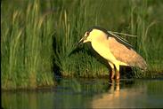
Interpretive signs at intervals explain something
of the ecology of the area, and there are parking
areas where you're supposed to get out and look at
things. As at most refuges, everyone just stops on
the loop wherever they want and meanders along the
road on foot. With traffic so low, they let you
drive both direction on the loop road, too.
 During
high water years, avocet and stilt will nest right
on the road where it passes fields, outside as well
as inside the refuge proper. Much of surrounding
area is owned by duck clubs, which kill foxes (did I
mention they kill foxes?) and sell grazing leases so
birders can see cattle egrets. Depending on water
levels, these fields might be full of ibis.
During
high water years, avocet and stilt will nest right
on the road where it passes fields, outside as well
as inside the refuge proper. Much of surrounding
area is owned by duck clubs, which kill foxes (did I
mention they kill foxes?) and sell grazing leases so
birders can see cattle egrets. Depending on water
levels, these fields might be full of ibis.
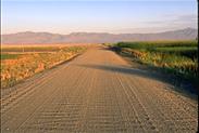
I included the rather dull photo of the gravel
road to give me an excuse to tell a story. This past
spring (1997), Dan Smith, a Brigham City
photographer, staked out 60 stilt and avocet nests
along this road during spring flooding. The refuge
personnel worked out an agreement with the county to
only grade the center portion of 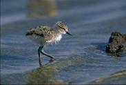 this damaged gravel road, in order to avoid
destroying the nests. Lo and behold, the county
bladed both shoulders as well, probably due to poor
communications in the road department (I'll give
them the benefit of the doubt - this year). Scratch
60 nests.
this damaged gravel road, in order to avoid
destroying the nests. Lo and behold, the county
bladed both shoulders as well, probably due to poor
communications in the road department (I'll give
them the benefit of the doubt - this year). Scratch
60 nests.
Dan posted information on photo.net
nature photography Q&A forum, and readers 'round
the country mailed letters expressing their concern
(disgust?) to the Box Elder County Commission.
The County has promised to ensure it doesn't
happen again. Don't underestimate the power of
public protest, or the usefulness of the net as a
tool for organizing protest.
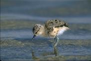
The avocet chick photos included in this section
were hatched early alongside a paved section of the
road - if you expand the photos by clicking on them
and look closely, you can see the pavement under the
inch of so of water they're walking through.
Photographing At The Refuge
 This refuge is a great place to photograph. I've
already touched on some of the reasons, such as the
low use it gets and the attractive species which
breed here. The birds which do breed here tend to be
easier to photograph than their counterparts at Malheur,
mostly because they occur in much larger numbers in
areas open to the public. Malheur,
for instance, is host to large numbers of breeding
grebes but they are on Malheur Lake, a portion of
the refuge closed
This refuge is a great place to photograph. I've
already touched on some of the reasons, such as the
low use it gets and the attractive species which
breed here. The birds which do breed here tend to be
easier to photograph than their counterparts at Malheur,
mostly because they occur in much larger numbers in
areas open to the public. Malheur,
for instance, is host to large numbers of breeding
grebes but they are on Malheur Lake, a portion of
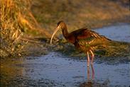
the refuge closed 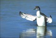 to visitors. As many white-faced ibis breed at Malheur
and the surrounding areas as at the Bear River
refuge, but they hang out in flood-irrigated fields
which, by the time they arrive in large numbers,
have grown to the point that you normally can only
see ibis heads, rather than the whole bird, as they
forage for food. At Bear River, ibis are much more
obvious and visible.
to visitors. As many white-faced ibis breed at Malheur
and the surrounding areas as at the Bear River
refuge, but they hang out in flood-irrigated fields
which, by the time they arrive in large numbers,
have grown to the point that you normally can only
see ibis heads, rather than the whole bird, as they
forage for food. At Bear River, ibis are much more
obvious and visible.
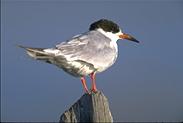 On the other hand, photographing black-crowned
night-heron, snowy egrets, American avocet and
black-necked stilts is easier at Bear River
Migratory Bird Refuge than at Malheur
because they occur here in vastly greater numbers
during the breeding season. And waterfowl blanket
the refuge while migrating.
On the other hand, photographing black-crowned
night-heron, snowy egrets, American avocet and
black-necked stilts is easier at Bear River
Migratory Bird Refuge than at Malheur
because they occur here in vastly greater numbers
during the breeding season. And waterfowl blanket
the refuge while migrating.
So, what's the catch? Why do I concentrate so
heavily on photographing at Malheur?
Mostly because the Oregon refuge has a much wider
variety of bird habitat to explore and photograph,
on and off the refuge. The species which are easy to
photograph at Bear River are great, but passerines,
hawks, owls, and and other kinds of birds are
relatively scarce, especially more uncommon species.
Other Places To See
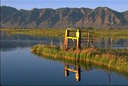 The Bear River refuge lies conveniently close to
the Wellesvilles range, which in fall is used by
several thousand migrating raptors. The range can be
seen the the photo on the left side of this
paragraph. The Bear Range east of Logan is home to
montane species and has spectacular late summer
wildflower displays. Both mountain ranges blaze with
reds, oranges, and yellows in the fall.
The Bear River refuge lies conveniently close to
the Wellesvilles range, which in fall is used by
several thousand migrating raptors. The range can be
seen the the photo on the left side of this
paragraph. The Bear Range east of Logan is home to
montane species and has spectacular late summer
wildflower displays. Both mountain ranges blaze with
reds, oranges, and yellows in the fall.
Bear River valley, north of the refuge, is good
for passerine birding, being the westernmost home of
lark bunting and in general being a blending area
for birds which call the Great Basin home, and those
whose range doesn't extend west across it. The north
shore of the Great Salt Lake, west of Golden Spike
National Monument, has some 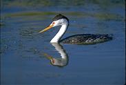 good sage-steppe habitat to explore. Expect to
find sage thrasher, burrowing owls, Brewer's sparrow
and other birds of the sage-steppe community here.
There's a sharp-tailed grouse lek on the monument,
but when I stopped by National Park Service folks
had heard the news but were clueless about its
whereabouts.
good sage-steppe habitat to explore. Expect to
find sage thrasher, burrowing owls, Brewer's sparrow
and other birds of the sage-steppe community here.
There's a sharp-tailed grouse lek on the monument,
but when I stopped by National Park Service folks
had heard the news but were clueless about its
whereabouts.
There's a winter bald eagle roost in a valley
east of the town of Willard. The eagles leave the
roost at first light and can often be found
scavenging waterfowl or roosting in cottonwoods in
the Willard Bay area.
If you choose to visit the area, keep in mind
that Jackson, Wyoming is only a few hours away. The
drive there takes you through Logan Canyon and over
the Bear Range. Tony Grove Lake, in the Bear Range
just a few miles off the highway, is a great
starting place for day hiking in the range, and Bear
Lake, which borders the range on the east, is a
significant waterfowl area.
Of course, like many nature photographers, when
I've headed up Logan Pass on my way to Jackson, I've
found it difficult to stop. The Grand Tetons and
Yellowstone National Park are hard to resist!
Getting There, Where To Stay,
Other Resources
Before leaving home, you'll want to print out and
study a checklist of birds found at the refuge.
 The refuge lies 15 miles west of Brigham City,
about an hour north of Salt Lake City on Interstate
15. Despite the sign, most folks in town seem
unaware of its existence. Brigham City is a tidy
Mormon town, neat and clean, with a handful of
motels and restaurants. The correct exit to take off
Interstate 15 if you wish to go directly to the
refuge is well marked, and there's signage on
Brigham City's sole major street as well if you
choose to go into town, first. Enjoy the small-town
atmosphere while you can, because Utah intends to
pack 5 million people along the strip between the
Wasatch Front and the Great Salt Lake over the next
couple of decades.
The refuge lies 15 miles west of Brigham City,
about an hour north of Salt Lake City on Interstate
15. Despite the sign, most folks in town seem
unaware of its existence. Brigham City is a tidy
Mormon town, neat and clean, with a handful of
motels and restaurants. The correct exit to take off
Interstate 15 if you wish to go directly to the
refuge is well marked, and there's signage on
Brigham City's sole major street as well if you
choose to go into town, first. Enjoy the small-town
atmosphere while you can, because Utah intends to
pack 5 million people along the strip between the
Wasatch Front and the Great Salt Lake over the next
couple of decades.
Note: This information was provided by Don Baccus,
a software engineer, naturalist, freelance
photographer and writer from Portland, Oregon.
All photographs
copyright © 1996, Don Baccus