Located in the heart of Idaho in
probably the most sparsely populated region, the Lost River Valley runs
75
miles from Arco through the great wild-west town of Mackay
and on to Willow
Creek Summit south of Challis. Dominating the
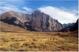
valley's skyline in almost every direction are rugged mountains
with several peaks reaching well above 12,000 feet
in elevation.
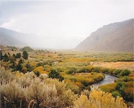
Sagebrush
and grassland canvas much
of the Lost River Valley.
 |
At 6000 feet in elevation the scenery in the valley changes dramatically. From
the north end you will enter a narrow rock canyon where odd rock formations line
the zigzagging highway. As you pass through the canyon
you can't help but notice exposed rock layers
representative of successive steps back in time. At
the end of the canyon it will give way to a elevated
view of the broad Lost River Valley. Here you
will be exposed to one of Idaho's most scenic treasures.
For the next thirty miles sagebrush and brown grasslands
will landscape the valley. A short distance
away are Idaho's two tallest mountains, the Lost
River and Pioneer Mountain Ranges. The Lost River Range is an
area of fantastic cliffs, rock folds, spires, huge
peaks and vast vistas. Of the eleven peaks over
12,000 feet in elevation in Idaho, nine are on the
Lost River Range. The Pioneer Mountains are
equally as impressive with many peaks above 11,000
feet and one peak over 12,000 feet. Both
are abundant with wildlife and seldom will you not see
Pronghorn Antelope or Elk along the foothills
of these mighty ranges.
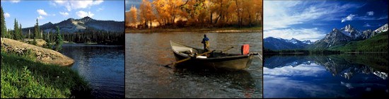
The Big Lost River
meandering through the valley floor above Mackay, Idaho.
 |
The
Pioneers are the headwaters for the Big Lost
River, a freestone river that meanders through the
valley until it reaches Mackay
Reservoir. Game fish species found in the Lost River Valley include
rainbow trout, brook trout, bull trout, cutthroat
trout, golden trout, mountain whitefish, and
grayling, but the Big Lost River is a predominantly
a Rainbow fishery. There are areas of excellent fishing
prior to Mackay Reservoir, however much of it runs
through private land. Some outfitters have elected to
obtained fishing rights from these land owners, most
anglers choose to utilize the public access at Mackay Reservoir.
Mackay Reservoir is a small reservoir and does have
camping and boat ramp facilities and is a favorite
to many retirees. In springtime high
water levels reach willows and shrubs that line the
west bank of the reservoir thus creating an ideal
habitat for many fish. Fly-fisherman normally
have good success catching fish in this area.
The reservoir would probably see plenty more
fly-fisherman if not for the lamenting winds that
hound the Lost River Valley in spring.
Below the reservoir is where the Big Lost River becomes a quality
tailwater fishery. As the river flows toward
the town of Mackay the scenery changes
dramatically. Present along the river are tall
cottonwoods and lush grassland. The waters in
this section can be crystal clear and much of the
river is seldom wider the 20-30 feet across.
Seasoned anglers favor light tippets and many
love the finesse required to fish the river.
Fishing conditions are pretty much predicated by the
fluctuation
in water flow. Consequently high water
temperatures are key reason why fishing drops off
and this can be attributed to a variety of
reasons.
The caddis and mayfly hatches are normally in
full-swing by late April on into early June.
Unfortunately the river is not opened to fishing
until Memorial Day weekend. Some years with a low
runoff fishing in June can be excellent and
chances are good you'll end up with a finned pig if
a caddis pattern is properly presented. During a normal snow-melt and
runoff year, the
salmonfly hatch will begin mid-June or early
July. Unlike many of Idaho's other
tributaries the Big Lost does not see that much
pressure during the salmonfly hatch.
Part
2