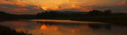
Dale Hollow
is one of the nation's premier smallmouth bass fisheries. In addition
to its famous bass, it is known for its ultra-clear water, high water
quality and undeveloped, pristine shorelines. Dale Hollow is the
current record holder for smallmouth bass. Other achievements include
a Tennessee state record for lake
 trout (12 pounds, 13 ounces). The
Obey River below Dale Hollow Dam produced a state record rainbow trout
(14 pounds, 8 ounces) and brown trout (26 pounds, 2 ounces). Finally,
the lake also holds the Kentucky muskie title at 43 pounds. The U.S.
Fish and Wildlife Service uses the clear, cold water from Dale Hollow
to operate a fish hatchery. This large facility has
recently been renovated and enlarged to increase trout production. Dale
Hollow Dam and Lake are under the jurisdiction of the U.S. Army Corps
of Engineers. The project was completed in 1943 for the purposes of
flood control, hydroelectric power production and to improve water
quality for domestic and industrial use. A number of day-use facilities
and campgrounds are located around the lake. A camping permit is
required for all designated primitive campsites. If restrooms are not
available at primitive campsites, campers are required to have
portable sanitation facilities. A number of informational signs and
buoys are found throughout the lake marking hazards, creek arms and
fish attractors. At the present time, there is no reciprocal fishing
agreement between Kentucky and Tennessee; a separate license is
required for each state's waters.
trout (12 pounds, 13 ounces). The
Obey River below Dale Hollow Dam produced a state record rainbow trout
(14 pounds, 8 ounces) and brown trout (26 pounds, 2 ounces). Finally,
the lake also holds the Kentucky muskie title at 43 pounds. The U.S.
Fish and Wildlife Service uses the clear, cold water from Dale Hollow
to operate a fish hatchery. This large facility has
recently been renovated and enlarged to increase trout production. Dale
Hollow Dam and Lake are under the jurisdiction of the U.S. Army Corps
of Engineers. The project was completed in 1943 for the purposes of
flood control, hydroelectric power production and to improve water
quality for domestic and industrial use. A number of day-use facilities
and campgrounds are located around the lake. A camping permit is
required for all designated primitive campsites. If restrooms are not
available at primitive campsites, campers are required to have
portable sanitation facilities. A number of informational signs and
buoys are found throughout the lake marking hazards, creek arms and
fish attractors. At the present time, there is no reciprocal fishing
agreement between Kentucky and Tennessee; a separate license is
required for each state's waters.
Minimum pool elevation is 631 feet
above mean sea level (msl) (21,880 acres), normal pool elevation is 651
feet msl (27,700 acres) and maximum flood control pool is 663 feet msl
(30,990 acres). Water fluctuations of 10 to 20 feet can occur throughout
the year. The U.S. Army Corps of Engineers controls water levels.
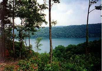
The entire shoreline is under the
jurisdiction of the U. S. Army Corps of Engineers. The length is 620
miles at normal summer pool. Most of the shoreline is heavily wooded,
and rock outcroppings are common. Development is restricted to marinas
and day-use areas.
Broken rock, boulders, gravel and
sand are the primary bottom materials. Extensive areas of bedrock
outcroppings are found along the shoreline.
Water clarity varies throughout
the lake, ranging from extremely clear by the dam to light green in the
creek arms. Summer secchi disc readings average between 18 and 20 feet.
Dale Hollow is fairly infertile, and there is adequate dissolved oxygen
throughout the water column. The remote location and lack of development
keeps the water quality quite high.
Primarily submergent varieties,
which include chara (sandgrass), coontail and several varieties of
pondweed. Due to the clear water, it is not uncommon to find weed growth
at the 30-foot level. Recently, Eurasian water milfoil has made an
appearance in limited areas. The steep drop-offs and winter drawdown
limit the development of emergent and floating vegetation.
Fishing licenses are required in both Kentucky and
Tennessee. A reciprocal fishing agreement provides for sport fishing
licenses from either state to be valid in the Wolf River, including
Illwill Creek, beginning at the state line as it crosses the Wolf River
at its mouth where it joins the Obey River. Creel limits and other
regulations of the state where the license was issued will apply.
Special permits are required in each state for trout fishing. Check
state laws for complete information. Licenses may be purchased at
County Clerk's offices, marinas and many other commercial establishments
in each state.
Hiking Trails
Red Oak Ridge Trail
Located 8 miles north of Celina, Tennessee off highway 53, hosts 18
miles of beautiful and scenic trails developed for horseback riding.
Beginning on a wooded ridge top, riders can descend to follow the
pristine Dale Hollow Shoreline. Seven loops provide for cutbacks to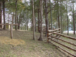 shorten or lengthen the trail. Eagles Bluff Overlook provides for one of
the most spectacular vistas of Dale Hollow Lake. Hikers are welcome. A
corral, storm shelter, and stalls are available. Free primitive camping
permit required for overnight stays. Alcoholic beverages are prohibited
and coggins papers required. Follow the signs toward Holly Creek Marina
and Red Oak Ridge.
shorten or lengthen the trail. Eagles Bluff Overlook provides for one of
the most spectacular vistas of Dale Hollow Lake. Hikers are welcome. A
corral, storm shelter, and stalls are available. Free primitive camping
permit required for overnight stays. Alcoholic beverages are prohibited
and coggins papers required. Follow the signs toward Holly Creek Marina
and Red Oak Ridge.
Accordion Bluff Hiking Trail
An 8-mile stretch of scenic trail that connects the
Lillydale and Willow Grove Campgrounds, both located
approximately 20 miles north of Livingston, Tennessee.
This natural soil surface trail winds along the shoreline
of Dale Hollow, ascends to the ridge-top and then returns
back toward the shoreline. The area is thickly forested
and contains some old growth timber. Accordion Bluff is
ideal for birders and wildflower enthusiasts. Parking is
available at each trailhead.